Top Ten Hikes in Southern Utah
Posted: June 15, 2017 | Author: Phenix Johnson | Read Time: 16 minutes
While the thought of southern Utah conjures up images of red rock, cowboys, and cattle in many visitors’ minds, those of us who are lucky enough to live in the area know that the wide variety of landscapes is what makes this the outdoor enthusiast's playground. A short hour drive south of Cedar City can take travelers to the smoldering red rock and slot canyon mazes, or if a visitor takes the opposite direction, one can find themselves atop a 11,000 ft peak surrounded by aspens, evergreens, and maybe even some snow hidden in the forest.
To help you get out and explore, we have put together a list of top ten hikes in southern Utah. From world-famous to local secrets, this list will help anyone discover the beautiful and diverse landscapes surrounding Southern Utah University.
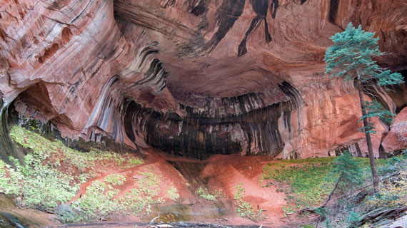
Cascade Falls: Dixie National Forest *Pet and family friendly*
Distance from SUU: 1 hour
Fee: None
Difficulty: Easy
Length: 1 mile round trip
Best Season: Spring, Summer, Fall
The Trail: This short trail is perfect for an afternoon adventure or a family hike. The trail goes along the edge of the Virgin River Valley, overlooking Zion in the distance. Starting in forest and heading out onto the rim, the trail is relatively flat, though there is a steep drop off to one side. Hikers will find breathtaking views at nearly every point in this trail, as well as water running down the cliffs to their right and over the trail in streams anywhere from a trickle to a small waterfall depending on the season. There are multiple places with benches to stop and have a snack, or just enjoy the view. The turnaround point ends in a deck, overlooking a waterfall tumbling out of a cave. This cave is a lava tube that not only drains nearby Navajo Lake, but also forms part of the headwaters for the Virgin River that is continuing to carve out Zion and the narrows today. Hikers will then turn around and take the trail back to their cars.
Getting There: From Cedar City, take the UT-14 east out of town. In 26 miles, turn right at the sign for Navajo Lake Rd. Follow this road for about half a mile, then turn left at the fork onto Cascade Falls Rd. This road winds down a hillside for about a mile then comes to another fork. This time turn right, and follow the road until it ends at the trailhead.
Taylor Creek- Kolob Canyons, Zion National Park *Family Friendly*
Distance from SUU: 20 min
Fee: $30 entrance fee to Zion
Difficulty: Easy
Length: 5.0 miles
Best Season: Fall, Spring
The Trail: Millions of visitors flock to Zion National Park every summer for the awe-inspiring cliffs of pink, red, and white, slot canyons, and the virgin river. Not many know about the Kolob region of Zion, about 40 miles north of the main canyon. This is truly Zion’s secret, no road connects the two parts of Zion, so Kolob has all the beauty and none of the crowds. One of the most stunning hikes is Taylor Creek, a family friendly adventure up a box canyon. From the trailhead, follow the trail as it goes down toward the creek. The trail will cross over the creek many times. While hiking, be on the lookout for two homestead cabins from the early 1900s. While visitors aren’t permitted inside the cabin, they make for a great picture and connection to the first settlers of the area. The trail ends at a double arch over an alcove to the hikers right. Enjoy the view and remember to preserve the beauty you’ve found by not taking the illegal trail up into the alcove.
Getting There: From Cedar City, take the southbound I-15 towards New Harmony. In 18 miles, take exit 40 toward Kolob Canyons and turn left at the stop sign. Proceed forward and park at the visitor center to pay Zion entrance fee.
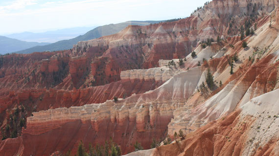
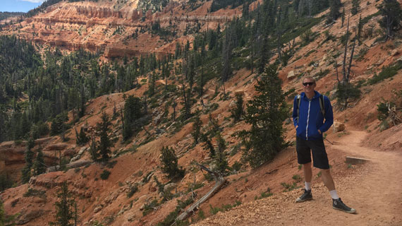
Spectra Point (& Ramparts Overlook) Trail: Cedar Breaks National Monument *Family Friendly*
Distance from SUU: 35 minutes
Fee: $5 per person
Difficulty: Easy
Length: 2 or 4 miles (depending on your preference)
Best Season: Summer, Fall
The Trail: Cedar Breaks National Monument is one of the best kept secrets in Utah. Located just a short drive from Cedar City, the monument is the same geological formation as Bryce Canyon. Stunning orange and red rock spires fill the half-mile deep natural amphitheater. Located at a higher altitude however, Cedar Breaks has a subalpine environment full of evergreens, aspens, and colorful displays of seasonal wild flowers. The Spectra Point Trail follows the rim of the amphitheater with spectacular view points at every turn. Wildflowers outline the trail during the spring, some of which can only be found at Cedar Breaks. Hikers should keep their eye out for a side trail leading away from the rim. Down this a small historic cabin can be found. Spectra Point is marked by a Bristlecone Pine Tree that is over 1,600 years old, the oldest in the park. Hikers can stop here and enjoy the world-class view of Cedar Breaks. If hikers wish to extend their hike, they can continue on towards Ramparts Overlook, a moderately rated hike. The extension turns the trail into 4 miles round trip. A picture perfect alpine forest lays to the hikers left, yet to the hikers right is an alien world of cliffs and hoodoos. The trail ends at Ramparts Overlook, where hikers turn around and ascend back up towards the visitor’s center.
Getting There: From Cedar City, take the UT-14 east out of town. In 18 miles, turn left onto UT-148 N. The visitor center and trailhead will be on your left in 3.5 miles.
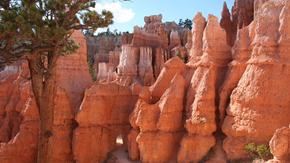
Queens Garden (& Navajo Loop Trail)- Bryce Canyon National Park *Family Friendly*
Distance from SUU: 1.5 hours
Fee: $30 entrance fee
Difficulty: Moderate
Length: 1.8 or 2.9 miles (depending on your preference)
Best Season: Spring, Summer, Fall
The Trail: One of the best ways to see Bryce Canyon from the inside, connecting the Queen's Garden trail to the Navajo Loop Trail allows for stunning views along both the rim and deep inside the amphitheater. Starting at Sunrise Point, hikers begin their descent into the maze of hoodoos on the Queen’s Garden Trail. As the trail switchbacks down, slithering its way in between towering hoodoos and red walls. As they get deeper into the amphitheater, hikers will pass through small tunnels made in the rock walls. The Queen’s Garden Trail forks off to the left halfway through the trail. This fork is marked by a sign, and a short walk from the fork is the trail’s namesake. A hoodoo formation that is said to look just like Queen Victoria. The formation is marked with a sign and picture for comparison. From this point, hikers will turn around back to the fork. They can either return the way they came, or continue on to connect to Navajo Loop Trail, famous for the last section called Wall Street. The giant ‘fins’ of rock that stretch hundreds of feet high narrow in this section, creating a unique and memorable ascent out of the amphitheater.
Getting There: From Cedar City, take UT 14 (E Center Street) east out of town. Follow this road through Cedar Canyon 41 miles. At the US-89 junction, turn left. In 21 miles, turn right onto UT-12, following the signs for Bryce Canyon National park. Turn right onto UT-63 S in 12 miles and drive through the town of Bryce to reach the park entrance.
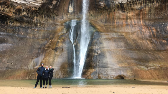
Lower Calf Creek Falls: Grand Staircase-Escalante National Monument *Pet and family friendly, water*
Distance from SUU: 3 hours
Fee: $5 parking fee
Difficulty: Moderate
Length: 6 miles
Best Season: Fall
The Trail: One of Grand Staircase-Escalante National Monument’s shining gems is Lower Calf Creek Falls. Located near the town of Boulder, Lower Calf Creek falls is a stunning hike through the famous Utah red rock. The trail begins in the parking lot of the Calf Creek Campground. The trail will take hikers past Native American ruins, so anyone interested should make sure to grab a pamphlet at the trailhead to know where to look. The sandy trails winds its way up a sandstone canyon for 3 miles before ending at the 126 foot high Lower Calf Creek Waterfall and glimmering blue pool below. Many hikers stop here to cool off in the water, have lunch, and take some instagram-worthy pictures before heading back down the canyon to their car.
Getting There: From Cedar City, take W. Center Street east out of town as it turns into UT-14. In 41 miles, turn left onto the US-89 N and follow it for 21 miles. Turn right onto UT-12 E and in 75 miles turn left into the Calf Creek Campground, where the trailhead is located.
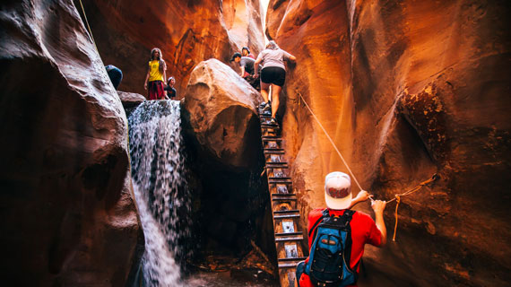
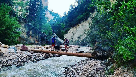
Kanarraville Falls- Kanarraville Town *Family friendly, pet friendly, water*
Distance from SUU: 30 minutes
Fee: $10 parking fee
Difficulty: Moderate
Length: 4.8 miles
Best Season: Summer, Fall
The Trail: World famous, Kanarraville Falls boasts an accessible slot canyon hike, complete with natural waterfalls for those brave enough to test the waters. Run by the town of Kanarraville, the hike has gotten popular in recent years due to the photogenic canyon. The hike begins at the wide mouth of a canyon. Cottonwood trees and sagebrush decorate the trail as it crosses over the creek and under the brush. Deeper into the canyon, the walls begin to close in around the trail. From here, hikers will trek through the stream up towards the falls. Truly a picturesque slot canyon, smooth sandstone walls, merely feet across at points, tower a hundred feet above with the humble, sparkling stream that forged it running from wall to wall. The first falls are reached shortly after entering the slot canyon, and they do not disappoint. A log with metal steps lays against the falls, with ropes to assist hikers up. The walls open up a bit after the first falls, and the second waterfall is a bit farther down. Here there are many places to rest, swim, and even slide down the falls. This is the end of the designated trail, and after a relaxing lunch, hikers turn around and head back. When hiking in slot canyons, always make sure to check the weather. Even if it is not raining on the trail, rain higher up could mean flash flooding below.
Getting There: From Cedar City, take the I-15 South towards Kanarraville Town. Take exit 51 towards Kanarraville/Hamilton Ft. Turn left onto Old U.S. 91 and follow it for 5 miles. Turn left onto E 100 N St. and the parking lot will be on the left in about a mile. There is a $10 parking fee.
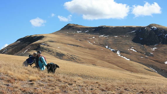
Delano Peak- Fishlake National Forest *Pet friendly, high elevation*
Distance from SUU: 1.5 hours
Fee: None
Difficulty: Moderate
Length: 4 miles
Best Season: Summer, Fall
The Trail: Delano Peak is the highest point in Beaver county, and one of the 200 most prominent mountains in the continental US. At about 12,000 feet of elevation this is a high elevation hike, which is one of the reasons it is rated as moderate. However, it is only a 4.8 mile round trip hike, with only around 2,000 feet of elevation gain. The trailhead starts on the ridge of the mountain above the treeline, making this hike relatively easy for the elevation of the peak. After parking, hikers will walk up an old jeep road towards a radio tower. After this, the road turns into a faint trail. The trail winds along the ridgeline, and can be faint at times. Hikers should stick to the ridge out of the valleys as they stroll through the rolling hills in the sky that make up Delano Peak. In contrast, the peak’s talus-covered sisters, Mt. Belknap and Baldy offer stunning alpine views, or a much more challenging hike, depending on how you look at it. Along the way, mountain goats graze in the green grass, sometimes in large numbers, and ancient lava flows frozen in time can be seen. The most challenging part of the hike is the last couple hundred feet, which juts into a steep uphill just below the peak. The peak is marked with a sign and a mailbox which holds the summit log. Hikers can leave their names, a picture, or a quote with the date of their summit. Hiking at high elevations takes a toll on the body, so make sure to drink plenty of water, take it slow, and listen to your body. If you or anyone in your group begins to get sick, head down right away.
Getting There: From Cedar City, take the I-15 North towards Beaver. Take exit 109 towards Beaver and turn right onto US 160 N. In 2 miles, turn right onto UT 153 and follow it up Beaver Canyon. In about 16 miles, turn left onto Big John Flat Road (Forest Road 123). Follow this dirt road for about 5 miles, sticking to the main, well graded road. It will take you through Big John Flat Campground, and up Delano Mountain to the ridge. There will be a small sign and a parking lot with a trail leading up to a radio tower. Park here and begin hiking.
Ashdown Gorge/Rattlesnake Creek Trail- Dixie National Forest *Pet friendly*
Distance from SUU : 45 minutes
Fee: None
Difficulty: Strenuous
Length: 9.8 miles
Best Season: Summer, Fall
The Trail: This downhill, point to point trail takes hikers from the high altitude of Cedar Breaks, through the Ashdown Gorge Wilderness, and into Rattlesnake Creek. This hike requires a shuttle, and can easily be turned into a short backpacking trail. From the trailhead, hikers will wind through the aspen forest along a fence line until reaching the rim of Cedar Breaks. The trail has small look out points that offer spectacular views, so photographers should keep an eye out for these faint trails on the left of the trail. From there, the hike descends steeply into the valley bellow Cedar Breaks. Four miles from the parking lot, the trail intersects with Rattlesnake Creek. From this point on, the trail follows the creek downstream and crosses through it many times. Hikers should be prepared to wade and walk through moving water. Ashdown Gorge is a stunning canyon, with shining silver walls, beautiful side canyons, and hidden waterfalls. Towards the end of the hike as the trail gets closer to Highway-14, on the right side of the canyon, on top of the canyon wall is Flanigan’s Arch. A precarious trail to the top is marked by a small wooden sign that nearly blends in with the rock. Once Scenic Highway-14 comes into sight high above the trail, there are a few cars that have been swept off the road in landslides that have occurred over the years. Some can be found in the middle of the creek while others are more hidden. Once under Highway-14, hikers can take the only steep uphill scramble to the road and the dirt lot where the shuttle car is parked.
Getting There: From Cedar City, take the UT-14 east out of town. At mile marker 7, park one car for a shuttle to get back up to the trailhead. In 18 miles, turn left onto UT-148 N. In a few miles you will get to Cedar Breaks National Monument. Continue straight to drive the 5 miles or so through the park. The parking lot and trailhead are just on the other side of the park exit on the left.
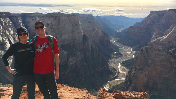
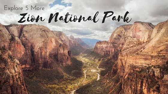
Observation Point- Zion National Park *Exposure*
Distance from SUU: 1.5 hours
Fee: $30 entrance fee
Difficulty: Strenuous
Length: 8 miles
Best Season: Spring, Summer, Fall
The Trail: One of the classic hikes in Zion, Observation Point is a steep ascent with dizzying views awaiting those who make it to the top, which is also the highest point in Zion. Starting from the Weeping Rock parking lot, the trail begins with switchbacks up the steep hill. From here, hikers get stunning views of Big Bend, a u-shaped turn in the Virgin River. The trail then reaches Echo Canyon, a stunning stretch of Zion’s famous sandstone formations, smooth waterfalls, and towering canyon walls. Be sure to bring a camera for this section of the trail. After the trail leaves Echo Canyon, the walls drop and suddenly hikers begin to get glimpses of the view that awaits them at the end. The end of the trail is a spectacular cliff edge overlooking all of Zion Canyon. Hikers can look down at Angels Landing, East Rim Trail, and the Great White Throne. After resting here, hikers can follow the same trail back to the parking lot. This is a strenuous steep trail, with just over 2,000 feet of elevation gain. Hikers should bring plenty of water and good shoes. When hiking in late fall or early spring, hikers should keep in mind that these higher-elevation areas will likely have snow or ice. Come prepared with proper footwear.
Getting There: From Cedar City, take the I-15 South towards St. George. In 31 miles, take exit 27 for UT-17 towards Toquerville. Turn left onto UT-9 and continue to follow this road until the park entrance. Once in the park, park your car and take the shuttle to the trail head.
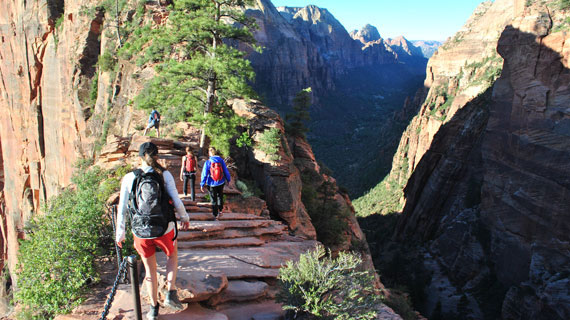
Angels Landing- Zion National Park *exposure*
Distance: 1.5 hours
Fee: $30 entrance fee
Difficulty: Strenuous
Length: 5.4 miles
Best Season: Spring, Fall, Early Summer
The Trail: One of the most famous hikes in the National Park System, Angels Landing is not for the faint of heart. From killer switchbacks to razor edge ridges, Angels Landing is a thrill seeker's dream. Beginning with a paved trail leading up to the dreaded ‘Walter’s Wiggles’, a set of roughly 20 switchbacks climbing up the steep terrain, the trail pushes hikers from the get-go. After these first two miles hikers reach the razor edge that gives the hike its infamy. For those afraid of heights or wishing for a less strenuous hike, Scouts Landing is just before the narrow ridge, and with great views, it makes for a good turnaround spot. For those who wish to continue, the ridge is at times only a few feet wide with sheer towering drops on either side. Hikers pull themselves up with chains that have been installed for safety the last half mile. The end is a platform of sandstone with 360 degree views. Once they’ve had their fill of the beauty, hikers pick their way down the razor edge and the rest of the trail. Because of such sheer drops at high elevation, this hike is not recommended for children or those with a fear of heights.
Getting There: From Cedar City, take the I-15 South towards St. George. In 31 miles, take exit 27 for UT-17 towards Toquerville. Turn left onto UT-9 and continue to follow this road until the park entrance. Once in the park, park your car and take the shuttle to the trail head.
From canyon to peak, and desert to river, there is something for everyone in our top-ten hikes in southern Utah. Rentals for water bladders, trekking poles, and canyoneering shoes for water hikes can all be found at SUU Outdoors on campus. While you’re out there exploring our backyard, make sure to take care of it and respect others. Always carry out any trash you make or find, yield to uphill hikers, clean up after pets, and stay on the trail. Many of your fellow hikers come to nature to feel isolated, so think about those around you before throwing that speaker in your backpack and blasting the top 40 on repeat. Now get out, go somewhere you’ve never been, see something you never seen, do something you’ve never done, and find out for yourself what makes these places so wonderful.
This article was published more than 3 years ago and might contain outdated information or broken links. As a result, its accuracy cannot be guaranteed.