GIS Students Fight Summer Wildfires
Published: February 03, 2022 | Author: Savannah Byers | Read Time: 3 minutes
 In times of crisis, it’s all hands on deck. As wildfires burned across the west coast this summer, Southern Utah University geographic information systems (GIS) students came together to process and map wildfire data for emergency response teams. The team of eight students, one professor, and a local company - Kolob Canyon Air Services - are one of five independent contractors in the U.S. who work with the United States Department of Agriculture Forest Service National Infrared Operations to record and track wildfire data for first responders.
“This wildfire season I was able to work with current students, previous students, and two future students,” said Professor David Maxwell, assistant professor of geographic information systems. “It was great to see the students work together and help each other learn the processes. I am proud of these students and the great job they did over this past fire season.”
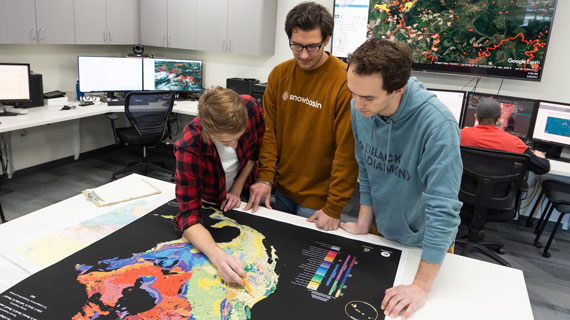
First responders prepare their approach for each fire by going through the data and maps that have been prepared by GIS teams. The information they process includes thermal readings, graphed hot spots, and a mapped border of the fire, as well as any other relevant information to fight the fire. These maps and data sets are updated on a regular basis, sometimes daily, depending on the size and severity of the fire.
“On large, fast moving fires, the map products have a very short life span,” Professor Maxwell said. “We deliver the data sets and maps to the emergency responders by 5:00 a.m., but the data is irrelevant by noon because the wildfire has changed by then.”
To collect data to process, airplanes with attached long-wave sensors track electromagnetic spectrums and to gather thermal imaging as they fly over the wildfire area. As the pilots fly the planes over the wildfires, they may be exposed to severe weather conditions, and sometimes the weather has been severe enough to call off flights entirely. The pilots also must fly the planes perfectly parallel to the ground to ensure accurate imaging and data for the GIS teams to process. Single flights could take anywhere from two to four hours due to the meticulous standards for accurate data and imaging and the extreme weather conditions.
One of the GIS students, trained to handle the equipment in the airplane, ensures an accurate inertial measurement unit (IMU) before and during the data gathering process. The data gathered from the flights provides the team with information to create heat maps with delineated boundaries.
The team processed wildfire data on a daily basis from early July to mid-October. On a typical day, the imaging gathered from the airplanes would be delivered to the team anytime between 11:00 pm and 4a00 pm. The team would then work from about 10:00 pm to 6:00 am to deliver the data to the emergency responders before their daily briefing. The team would process anywhere from one to eight fires in a night, sometimes working long, late-night shifts.
As an interdisciplinary program, SUU’s GIS program serves a variety of departments and degrees at SUU. This program provides access to spatial technologies accompanied with knowledge, theory, and hands on experience in order to foster a diversity of geographic research.
SUU’s GIS program Director David Maxwell enjoys keeping up with as many of his GIS graduates as he can. In 2019, he was happy to report that 100% of his GIS graduates who have completed their capstone have earned a GIS position after graduation.
Graduates from the GIS program pursue many exciting careers after graduation from prestigious fellowships to leading GIS teams. Learn more about SUU’s GIS program.
Tags: GIS
Contact Information
435-586-5400
Contact the Office of Marketing Communication
This article was published more than 3 years ago and might contain outdated information or broken links. As a result, its accuracy cannot be guaranteed.